Planning Commission December 4 Study Meeting Agenda
November 27, 2019
CITY OF SOUTHFIELD
PLANNING COMMISSION STUDY MEETING
DECEMBER 4, 2019
COUNCIL CONFERENCE ROOM
6:30PM
AGENDA
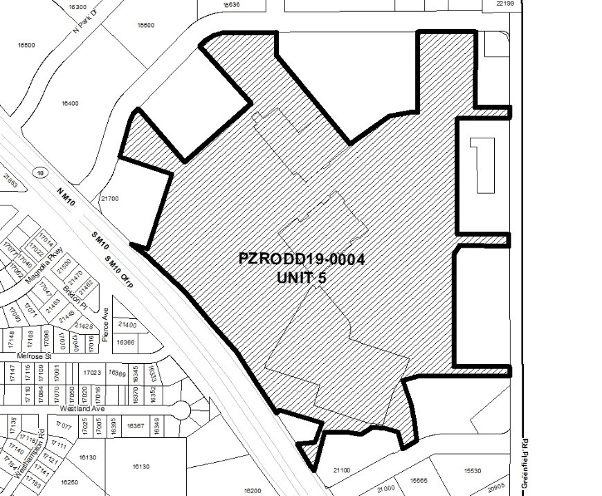
- PZRODD19-0004 is the Rezoning Request of Northland Renaissance Place Development, LLC, on behalf of the owner, City of Southfield, to amend the Northland Subarea Redevelopment Plan Overlay Development District to allow for the development of mixed-use commercial, office and residential buildings and uses, including Medical Marihuana Facilities, on property located at 21500 Northwestern Highway, Parent Sidwell Parcels 2436-476-028, -035, and -040, proposed sub-parcel Unit 5 described as follows: Part of East ½ of Section 36, T.1N., R10E., City of Southfield, Oakland County, Michigan, described as: Commencing at the Southeast corner of Section 36; thence N01°12’30”W 1,052.38 feet; thence S88º44’00”W 80.00 feet to a point on the west right of way line of Greenfield Road (140 feet wide); thence along said right of way line N01º12’30”W 498.79 feet to the Point of Beginning; thence S88º47’17”W 615.95 feet; thence along a curve to the left 113.42 feet, said curve having a radius of 250.00 feet, a central angle of 25º59’41” and a chord bearing S74º14’51”W 112.45 feet; thence S61°15’01”W 35.33 feet; thence 324.99 feet along a curve to the right, said curve having a radius of 852.68 feet, a central angle of 21º50’16” and a chord bearing S18°40’10”E 323.03 feet; thence S07º42’57”E 98.02 feet to a point on the north right of way line of Northland Drive (variable width); thence S59°47’40”W 37.57 feet along said right of way line; thence N12º23’36”W 126.18 feet; thence along a curve to the left 106.47 feet, said curve having a radius of 56.50 feet, a central angle of 107°58’15” and a chord bearing N66º22’49”W 91.40 feet, thence S59°38’06”W 173.47 feet; thence along a curve to the right 16.99 feet, said curve having a radius of 20.00 feet, a central angle of 48º39’50” and a chord bearing S83°57’55”W 16.48 feet; thence along a curve to the left 175.43 feet, said curve having a radius of 390.00 feet, a central angle of 25º46’22” and chord bearing N84°35’16”W 173.95 feet; thence S27º45’37”W 247.93 feet calculated (248.62 feet record) to a point on the northeasterly right of way line of Northwestern Highway (204 feet wide); thence along said right of way line N34°07’02”W 185.98 feet; thence N81º19’30”E 125.71 feet; thence N15°59’43”E 118.18 feet; thence N73º07’15”W 268.23 feet; thence S55°53’14”W 35.38 feet to a point on the northeasterly right of way of said Northwestern Highway thence N34º07’02”W 47.88 feet; thence along a curve to the left 729.73 feet, said curve having a radius of 4,625.35 feet, a central angle 09°02’22” and a chord bearing N38º38’18”W 728.97 feet; thence along a curve to the left 484.10 feet, said curve having a radius of 7,529.99 feet, a central angle of 03°41’01” and a chord bearing N45º00’00”W 484.02 feet; thence N46°50’06”W 159.12 feet; thence S70º54’00”E 110.61 feet calculated (110.66 feet record); thence N17°39’00”E 500.91 feet; thence N72º39’30”W 313.08 feet; thence S75°51’28”W 52.22 feet to a point on the south right of way line of J.L. Hudson Drive (variable width); thence along said right of way line N16º22’07”E 242.15 feet; thence along the curve to the right 110.85 feet, said curve having a radius of 237.00 feet, a central angle of 26°47’53” and a chord bearing N29º46’04”E 109.84 feet; thence N43°10’00”E .05 feet; thence S42º11’22”E 448.00 feet; thence N47°22’54”E 559.00 feet; thence N42º30’10”W 489.01 feet to a point on the south right of way line of said J.L. Hudson Drive; thence along said right of way line N43°10’00”E 10.83 feet; thence along a curve to the right 187.76 feet, said curve having a radius of 237.00 feet, a central angle of 45º23’30” and chord bearing N65°51’45”E 182.89 feet; thence N88º33’30”E 298.70 feet; thence S01°26’28”E 68.18 feet; thence 68.36 feet along a curve to the left, said curve having a radius of 100.00 feet, a central angle of 39º09’53” and a chord bearing S21°01’24”E 67.03 feet; thence S40º33’04”E 778.20 feet; thence N49°23’39”E 253.09 feet; thence 170.89 feet along a curve to the right, said curve having a radius of 250.00 feet, a central angle of 39º09’53” and a chord bearing N68°58’36”E 167.58 feet; thence N88º33’32”E 31.07 feet; thence N01°26’28”W 519.17 feet to a point on said right of way line of J.L. Hudson Drive; thence along said right of way line N88º33’30”E 378.51 feet; thence S45°06’23”W 21.14 feet; thence S01º15’00”E 468.18 feet; thence N88°45’00”E 180.95 feet; thence N64º33’36”E 40.44 feet calculated (40.46 feet record) to a point on the west right of way line of said Greenfield Road: thence along said right of way line S01°15’00”E 88.18 feet; thence S88º45’02”W 250.00 feet; thence S01°14’18”E 729.34 feet; thence N88º47’32”E 250.00 feet to a point on said right of way line of Greenfield Road; thence along said right of way line S01°12’30”E 83.00 feet; thence S88º47’32”W 263.00 feet; thence S01°12’30”E 751.44 feet; thence N88º47’17”E 263.00 feet to a point on said right of way line of Greenfield Road; thence along said right of way line S01°12’30”E 55.00 feet to the Point of Beginning. Said description contains 3,732,431 square feet, or 85.68 acres, more or less, City of Southfield, Oakland County, State of Michigan.
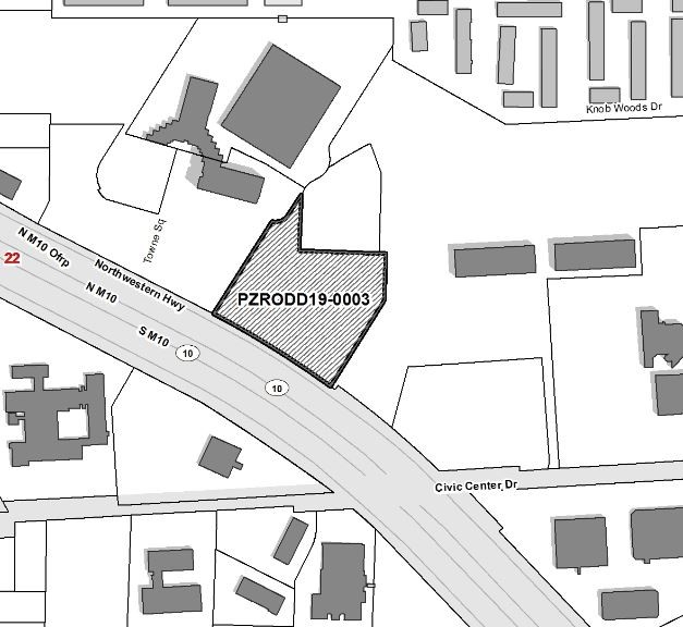
- PZRODD19-0003 is the Rezoning Request of Avanti Development Group, LLC, on behalf of the owner, Oakland Commons, LLC, to rezone 5.65 acres of property from RC – Regional Center to ODD – Overlay Development District and create a Master Development Plan and Agreement to allow for the development of two hotels, including an extended stay hotel, with associated parking and other on-site amenities, Sidwell Parcel 2422-201-023, on the north side of the Northwestern Service Drive between Civic Center Drive and Towne Square, City of Southfield, Oakland County, State of Michigan.
- PSP19-0009 is the Site Plan Review Request of GMB Architecture and Engineering, on behalf of the owner, Yeshiva Beth Yehudah School, for the construction of a 23,301gsf third floor addition to the existing school with associated parking and other on-site amenities on property located at 15751 Lincoln Drive, Sidwell Parcel 2424-427-022, N 100 Ft Of Lot 15, Also 1/2 Of Vac Fairfax Ave Adj To Same, Also All Of Lot 16, Also 1/2 Of Vac Fairfax Ave Adj To Same, Also E 1/2 Of Lot 17, Also 1/2 Of Vac Fairfax Ave Adj To Same of Superv Plat Meadow Downs 2, on the south side of the Lincoln Drive between Greenfield Road and the I-696 Freeway, City of Southfield, Oakland County, State of Michigan.
- PSP19-0010 is the Site Plan Review Request of Friedman Real Estate Group, on behalf of the owner, Southfield Galleria Owner LLC, for the construction of a 95,525gsf research and development center with associated parking and other on-site amenities on property located at 200 Galleria Officentre, Sidwell Parcel 2417-176-008, on the north side of the Northwestern Service Drive between Lockdale and Case Roads, City of Southfield, Oakland County, State of Michigan.
- Public Comment – A person addressing the Commission shall be limited to a period of three (3) minutes unless such period of time is extended by the presiding officer or by majority vote of the Commission.
- Minutes: November 6, 2019 Study Meeting
November 20, 2019 Special Meeting
- Miscellaneous: